![](/images/other/stat-length.png)
![Trail Walking Les Hôpitaux-Neufs - depart les hopitaux neufs version 2 - Photo](https://media.geolcdn.com/t/1900/400/ext.pjpeg?maxdim=2&url=https%3A%2F%2Fstatic1.geolcdn.com%2Fsiteimages%2Fupload%2Ffiles%2F1553511878bg_sport_marche.png)
depart les hopitaux neufs version 2
gerardmicheline
User
![Length](/images/other/stat-length.png)
Length
15.3 km
![Max alt](https://static1.geolcdn.com/siteimages/upload/files/1508320355ic_sort_altitude_max_24dp.png)
Max alt
1301 m
![Uphill gradient](https://static1.geolcdn.com/siteimages/upload/files/1508320355ic_sort_den_pos_24dp.png)
Uphill gradient
495 m
![Km-Effort](/images/other/stat-length.png)
Km-Effort
22 km
![Min alt](https://static1.geolcdn.com/siteimages/upload/files/1508320355ic_sort_altitude_min_24dp.png)
Min alt
998 m
![Downhill gradient](https://static1.geolcdn.com/siteimages/upload/files/1508320355ic_sort_den_neg_24dp.png)
Downhill gradient
495 m
![Boucle](https://static1.geolcdn.com/siteimages/upload/files/16400158638029165_repeat_loop_refresh_sync_direction_icon.png)
Boucle
Yes
Creation date :
2021-01-13 14:34:18.421
Updated on :
2021-01-13 14:37:29.034
![Walking](https://static1.geolcdn.com/sitytour/trail-icons/101.png)
4h36
Difficulty : Very difficult
![Scan this QR Code to open this trail in the SityTrail application](https://capi.geolives.com/qq0zvz2zws4bq2lad0pu/sitytour/trails/2639803/qr.png?size=200)
FREE GPS app for hiking
About
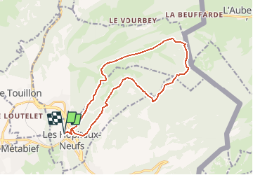
Trail Walking of 15.3 km to be discovered at Bourgogne-Franche-Comté, Doubs, Les Hôpitaux-Neufs. This trail is proposed by gerardmicheline.
Description
le mont herba ;crée a partir de la première version raquette un peu laborieuse faite le 12/1/2021 en evitant les pistes de fond
Positioning
Country:
France
Region :
Bourgogne-Franche-Comté
Department/Province :
Doubs
Municipality :
Les Hôpitaux-Neufs
Location:
Unknown
Start:(Dec)
Start:(UTM)
299436 ; 5183900 (32T) N.
Comments
Trails nearby
![Trail Walking Métabief - GTJ Metabief - Pontarlier - Photo](https://media.geolcdn.com/t/375/260/ext.jpg?maxdim=2&url=https%3A%2F%2Fstatic1.geolcdn.com%2Fsiteimages%2Fupload%2Ffiles%2F1553511878bg_sport_marche.png)
![Walking Walking](https://static1.geolcdn.com/sitytour/trail-icons/101.png)
GTJ Metabief - Pontarlier
Walking
Medium
(1)
Métabief,
Bourgogne-Franche-Comté,
Doubs,
France
![](/images/other/stat-length.png)
25 km | 35 km-effort
7h 17min
![](https://static1.geolcdn.com/siteimages/upload/files/16400158638029165_repeat_loop_refresh_sync_direction_icon.png)
No
![Trail Walking Métabief - Le mont d 0r - Photo](https://media.geolcdn.com/t/375/260/dfbdcbfb-f5e1-43ae-8768-86e7f8471cb6.jpg&format=jpg&maxdim=2)
![Walking Walking](https://static1.geolcdn.com/sitytour/trail-icons/101.png)
Le mont d 0r
Walking
Medium
Métabief,
Bourgogne-Franche-Comté,
Doubs,
France
![](/images/other/stat-length.png)
18.5 km | 25 km-effort
4h 38min
![](https://static1.geolcdn.com/siteimages/upload/files/16400158638029165_repeat_loop_refresh_sync_direction_icon.png)
No
![Trail Walking Saint-Antoine - Boucle du fort St Antoine - Photo](https://media.geolcdn.com/t/375/260/39387965-6cd2-4b9c-a9a7-b089cab08bc2.jpg&format=jpg&maxdim=2)
![Walking Walking](https://static1.geolcdn.com/sitytour/trail-icons/101.png)
Boucle du fort St Antoine
Walking
Medium
Saint-Antoine,
Bourgogne-Franche-Comté,
Doubs,
France
![](/images/other/stat-length.png)
4.8 km | 6.2 km-effort
1h 25min
![](https://static1.geolcdn.com/siteimages/upload/files/16400158638029165_repeat_loop_refresh_sync_direction_icon.png)
Yes
![Trail On foot Les Fourgs - Le Sentier des Bornes - Photo](https://media.geolcdn.com/t/375/260/4777e0b5-35d9-430b-b18b-01a7bbd1a8dc.jpeg&format=jpg&maxdim=2)
![On foot On foot](https://static1.geolcdn.com/sitytour/trail-icons/100.png)
Le Sentier des Bornes
On foot
Easy
Les Fourgs,
Bourgogne-Franche-Comté,
Doubs,
France
![](/images/other/stat-length.png)
6.4 km | 8 km-effort
1h 48min
![](https://static1.geolcdn.com/siteimages/upload/files/16400158638029165_repeat_loop_refresh_sync_direction_icon.png)
No
![Trail On foot Malbuisson - Sentier du Tour du Lac - Photo](https://media.geolcdn.com/t/375/260/ec9f6be9-4d56-4db2-b65f-5890444a2963.jpeg&format=jpg&maxdim=2)
![On foot On foot](https://static1.geolcdn.com/sitytour/trail-icons/100.png)
Sentier du Tour du Lac
On foot
Easy
Malbuisson,
Bourgogne-Franche-Comté,
Doubs,
France
![](/images/other/stat-length.png)
16 km | 19.9 km-effort
4h 30min
![](https://static1.geolcdn.com/siteimages/upload/files/16400158638029165_repeat_loop_refresh_sync_direction_icon.png)
No
![Trail Snowshoes Métabief - Les hauteurs de Metabief - Photo](https://media.geolcdn.com/t/375/260/33f04111-8af2-4c09-927f-ba23e9559149.jpg&format=jpg&maxdim=2)
![Snowshoes Snowshoes](https://static1.geolcdn.com/sitytour/trail-icons/504.png)
Les hauteurs de Metabief
Snowshoes
Medium
(1)
Métabief,
Bourgogne-Franche-Comté,
Doubs,
France
![](/images/other/stat-length.png)
15.5 km | 23 km-effort
3h 51min
![](https://static1.geolcdn.com/siteimages/upload/files/16400158638029165_repeat_loop_refresh_sync_direction_icon.png)
Yes
![Trail Nordic walking Malbuisson - Fort St Antoine - Photo](https://media.geolcdn.com/t/375/260/fe4e7a22-394a-4da9-be49-1254fdb85bde.jpg&format=jpg&maxdim=2)
![Nordic walking Nordic walking](https://static1.geolcdn.com/sitytour/trail-icons/102.png)
Fort St Antoine
Nordic walking
Easy
Malbuisson,
Bourgogne-Franche-Comté,
Doubs,
France
![](/images/other/stat-length.png)
5.8 km | 7.3 km-effort
2h 21min
![](https://static1.geolcdn.com/siteimages/upload/files/16400158638029165_repeat_loop_refresh_sync_direction_icon.png)
Yes
![Trail Cross-country skiing Les Hôpitaux-Vieux - Les Essarts - Photo](https://media.geolcdn.com/t/375/260/133bf42f-84e7-4637-b480-7581e8a779ca.jpg&format=jpg&maxdim=2)
![Cross-country skiing Cross-country skiing](https://static1.geolcdn.com/sitytour/trail-icons/502.png)
Les Essarts
Cross-country skiing
Easy
Les Hôpitaux-Vieux,
Bourgogne-Franche-Comté,
Doubs,
France
![](/images/other/stat-length.png)
6.5 km | 8.1 km-effort
2h 3min
![](https://static1.geolcdn.com/siteimages/upload/files/16400158638029165_repeat_loop_refresh_sync_direction_icon.png)
Yes
![Trail Walking Jougne - La Jougnena - Photo](https://media.geolcdn.com/t/375/260/ext.jpg?maxdim=2&url=https%3A%2F%2Fstatic1.geolcdn.com%2Fsiteimages%2Fupload%2Ffiles%2F1553511878bg_sport_marche.png)
![Walking Walking](https://static1.geolcdn.com/sitytour/trail-icons/101.png)
La Jougnena
Walking
Very difficult
(1)
Jougne,
Bourgogne-Franche-Comté,
Doubs,
France
![](/images/other/stat-length.png)
17.7 km | 24 km-effort
5h 32min
![](https://static1.geolcdn.com/siteimages/upload/files/16400158638029165_repeat_loop_refresh_sync_direction_icon.png)
Yes